桃浦中央绿地 上海
James Corner Field Operations
“这座位于上海西北部地区的新中央公园,从原本遭受污染的工业区转变为绿植密布的多生态环境,将生物多样性带入了密集的城市。桃浦中央绿地实现了70%的树木覆盖率,成为了城市的“疗愈之肺”,同时它还提供了充足的公共空间,使人们可以在237英亩的开放场地内进行各类休闲活动。公园的湿地周围实施了防洪策略(包括公路处的可渗透表面),巨大的地下水池每天能够储存近800万加仑的水。岛屿、桥梁和凉亭为公园游客带来了各种与水生栖息地重新接触的机会和体验。”
– 2020年评审委员会
项目概述
桃浦中央绿地是上海桃浦智创城的一道“疗愈之肺”,其设计以中国传统文化中优雅的流动之美为灵感,借助步道、水道与地形构成的动态网络来改善水质、管理雨水并提供精巧细致的土壤修复策略,同时创造了新的连接,将原先的工业用地转变为充满活力的生态系统和新型的城市生态公园。
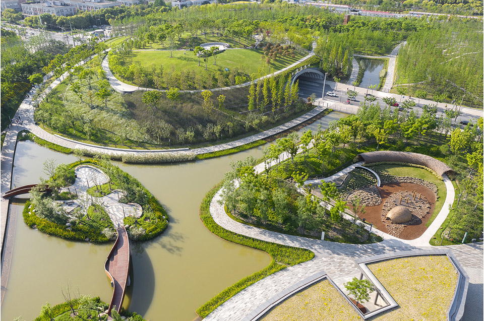
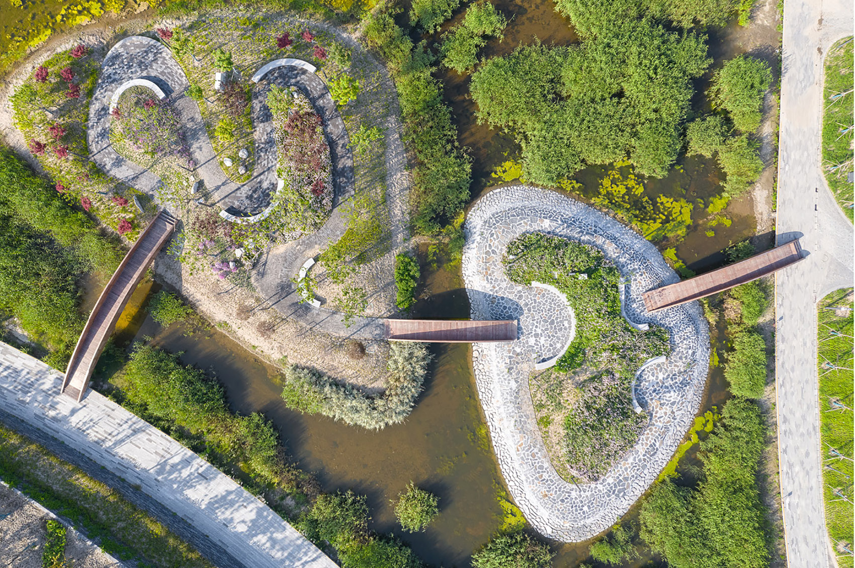
桃浦中央绿地打破了国内许多公园的固有模式,陆桥和隧道在满足基础道路设施需求的同时,还创造出一个庞大且连续的公园。设计将行人安全放在首要位置,致力于加强邻里互动,并在此基础上创造了栖息地和野生动物走廊。最终这座规模宏大、面积达到237英亩(约959,105平方米)的公园以令人瞩目的方式重新定义了城市与水的关系,在密集的城市背景下营造出大自然般的体验,通过一系列栖息地、水体、活动空间和展示空间来为21世纪的都市生活提供支持。

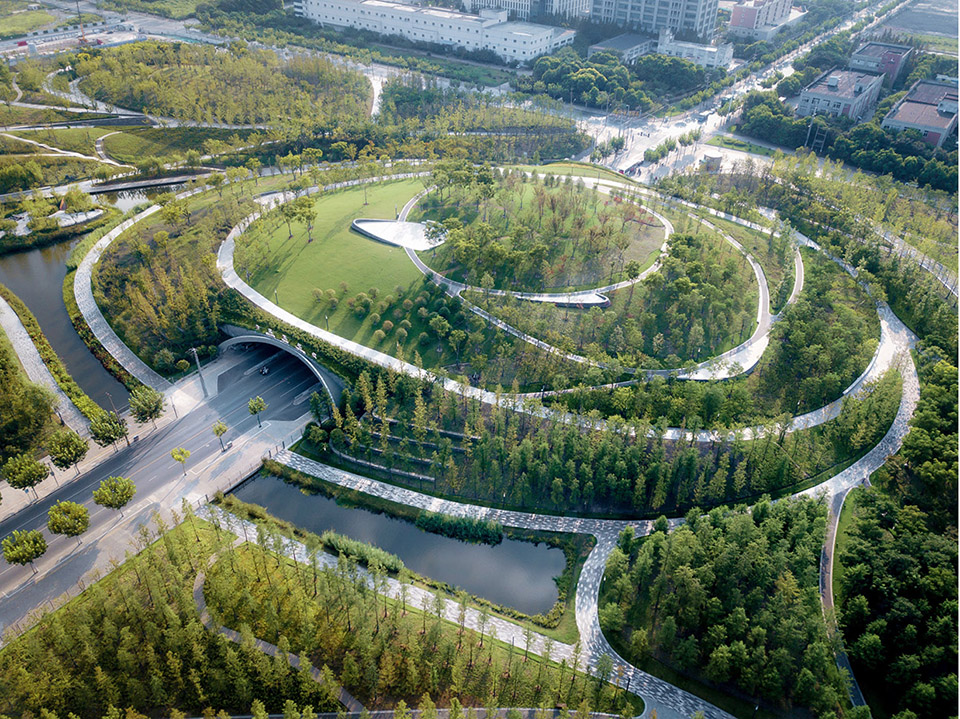
▲鸟瞰:桃浦中央绿地打破了中国许多公园的固有模式。路上桥梁和隧道在满足道路基础设施需要的同时创造出一个庞大且连续的公园,优先考虑了行人的安全,加强了邻里联系,创造出新的栖息地和野生动物走廊。
项目说明
桃浦智创城
在过去的30年间,上海被迫承受着因城市增长而带来的前所未有的压力,其都市形态也逐渐从同心圆模式转变为多中心模式。这导致了一系列城市核心区的形成——它们各自拥有截然不同的特征,在高度互联的同时也通过各种交通途径与市中心形成强力的连接。随着上海的发展,许多位于郊区的工业地块得到了重新利用,桃浦也是其中之一。4.2平方公里的“桃浦智创城”是上海西北部新建设的科学与技术核心区,人口预计将增长至29000人。
桃浦在短时间内便经历了众多转变。1950年至1997年,它主要作为化学、制药、纺织和轻工业用地,且被认为是上海污染最严重的地区之一。1997-2000年,桃浦作为上海首批城市工业园区之一,见证了市政府治理“重污染”、实施产业转型的过程。2009年,桃浦的经济开始转向生产型服务业和高科技产业,与“创造工业发达且宜居的城市”的愿景相符合。2014年,区政府启动“桃浦智创城”项目,以期完成桃浦地区从受污染的工业用地向科技中心的转型。今天,桃浦中央绿地已成为桃浦智创城具有决定性作用的统一元素,在彰显“绿色生态城”精神的同时,也为智创城的整治和复垦工作提供了有效帮助。
新自然
新桃浦中央绿地既是一个有效运作的生态系统,同时也是繁华的商业、创意、休闲和娱乐中心。公园在过滤污染物和提供亟需的栖息地的同时,还对人、水、空气、土壤和野生动物的运动路线进行了精准布局。桃浦智创城的一个主要目标是,将具有良好连通性的独特公共空间作为高质量城市发展的催化剂,以推动经济增长和创新。这种“公园-城市共生”的关系让桃浦从上海的众多区域中脱颖而出,继而成为技术、文化与环境创新的标杆。桃浦中央绿地成功将当代的、可持续的、创新的城市发展形式与自然环境相结合,描绘出一幅可以成为上海乃至世界城市发展模型的蓝图。其成果是一座令人瞩目的、面积达到237英亩(约959,105平方米)的宏伟公园,它重新定义了城市与水的关系,犹如生长在密集城市环境中的一道“绿肺”,在带来自然气息的同时,也定义出了一个令人难忘的生态区域。公园中的栖息地、水源、活动空间和展示空间共同为21世纪的都市生活提供了支撑。
创新生态学
从亚洲绿色城市指数来看,上海是居民人均绿地面积最少的城市之一。市政府对该问题做出了回应,并制定了一套大都市尺度的规划方案,旨在提高公共领域的丰富性并连接孤立的生态系统。“上海绿色走廊”是该计划中最具前沿性的生态倡议,而桃浦中央绿地则作为规模最大的建造项目在其中发挥了关键作用。公园的设计以中国传统文化中优雅的流动之美为灵感,借助动态流畅的步道、水道和地形构成的动态网络来改善水质、管理雨水并提供精巧细致的土壤修复策略,同时创造了新的连接,将原先的工业用地转变为充满活力的生态系统和新型的城市生态公园。
水
上海是一个多雨的城市,拥有较高的地下水位,距离地表不到两米,因此特别需要防洪。作为回应,桃浦中央绿地的水系统与既有运河相连接,通过中央谷地让水通过曝气设施和净化湿地,以过滤并改善水质,同时收集水用于现场再利用。这些经过重塑的水道是公园设计最重要的特征之一,它将水净化技术作为景观的可见部分展示出来。桃浦智创城还是“海绵城市试点项目”的一部分,按照计划,到2030年,中国80%的城市地区将至少能够对70%的雨水进行吸收和再利用,以帮助应对气候变化。
在展示和教育的视角之外,游客们还可以通过许多其他方式来体验公园中的水:从柔软的湿地,到岛屿,到休闲湖泊,再到造型独特的城市码头。桃浦中央绿地下方是一个巨大的地下水池,每天可以储存约3万立方米的水,可以通过将水引至公园湖泊来减少附近的洪水风险,干旱时还能起到储水的作用。公园的建造使用了多种新型材料,例如用于铺设道路的透水沥青,能够允许水以每分钟4000公升的速度下渗;还有由锯屑制成的ASWOOD材料,能够让水穿透地表直接到达植物根部。
地形
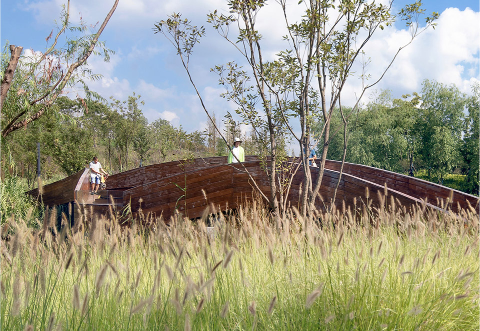
为了妥善应对场地中的工业遗产,有必要进行大规模的土方工程,包括挖掘、迁移和对受污染土壤的覆盖。项目采取了在现场管理土壤而非迁往别处的做法,有助于实现更长久的生态效益。不同于上海的平坦地貌,该场地的粗糙土层提供了一个如雕塑般起伏的地形基础,并由此带来山谷般的体验,使游客们得以欣赏到城市和公园本身的绝妙景观。设置于森林内的瞭望塔带来了新的视野,营造出一种仿佛同时沉浸于城市与自然的感受。
绿肺
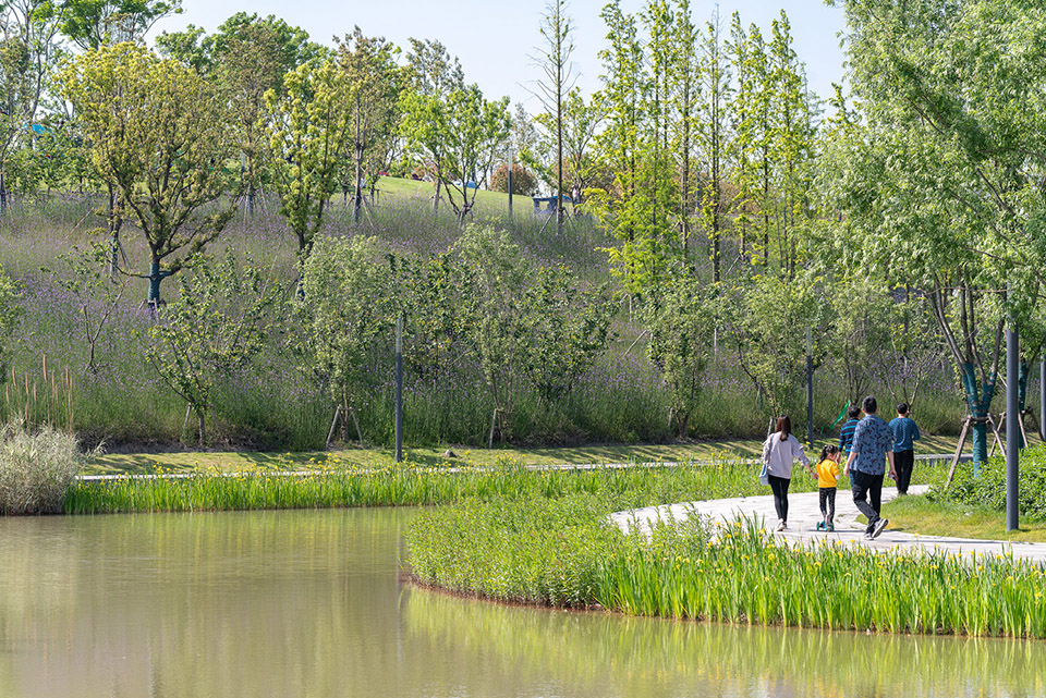
桃浦绿地在密集的城市环境中创造出了一种广阔的自然感。场地的树木覆盖率达到70%,为公园提供了充足的绿荫,同时也为该地区的碳固存做出了贡献。树木与地形共同定义了公园的边界,同时也塑造了其内部的体验。种植方面选择了适合上海气候的本地植物以及适应性强的树种,包括水杉、银杏、柳树、柏树和桃树等,它们均分布在中央水道的两侧。这些树种使人联想到当地曾经作为农业村落的历史,而两侧生长着桃树的溪流则直接呼应了“桃浦”的名称。一系列相互连接的岛屿——包括垂柳岛、枫树岛和桃花岛——为开阔且活跃的场地提供了宁静的空间,同时也增强了整个公园的体验性和生物多样性。
连通性和无障碍性
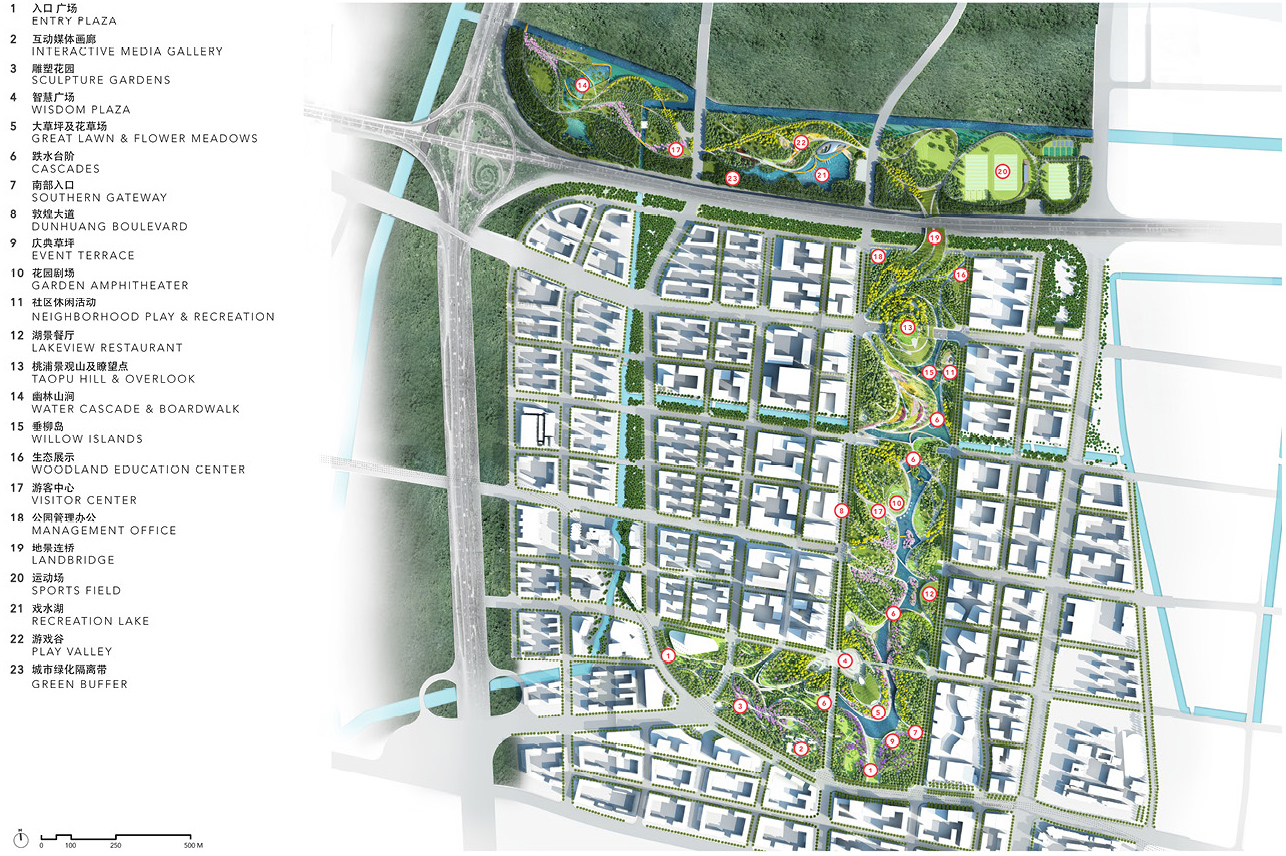
桃浦中央绿地打破了中国许多公园的固有模式。路上桥梁和隧道在满足道路基础设施需要的同时创造出一个庞大且连续的公园,优先考虑了行人的安全,加强了邻里联系,创造出新的栖息地和野生动物走廊。在公园的中央位置,位于古浪路上的“桃浦景观山及瞭望点”提供了一个视野开阔的赏景平台,其下方的隧道则连接着东西方向的交通。作为桃浦中心区的最高点,“桃浦景观山及瞭望点”开辟了欣赏上海城市景色的新视角。
零售空间、地下商业区和文化空间通过一条连续互通的路径网络与公园的特色街道和景观连接起来,并且实现了各个空间的顺畅过渡。公园的主要出入口与地铁站或公交站的距离均在5分钟的步行范围内,提高了上海地区交通的便捷性。所有陆上桥梁和道路都经过了水平层级调整,以满足ADA的标准,一些特别置入的功能则确保了所有人群都能享受到设施的便利性。自然游乐场区域设有一系列用当地有机材料打造的定制元素,包括由当地工匠编织的竹制“毛毛虫隧道”和鼓励使用者自由玩耍的“竹茧”。
▲桃浦中央绿地以“新自然”作为核心概念,其设计以中国传统文化中优雅的流动之美为灵感。
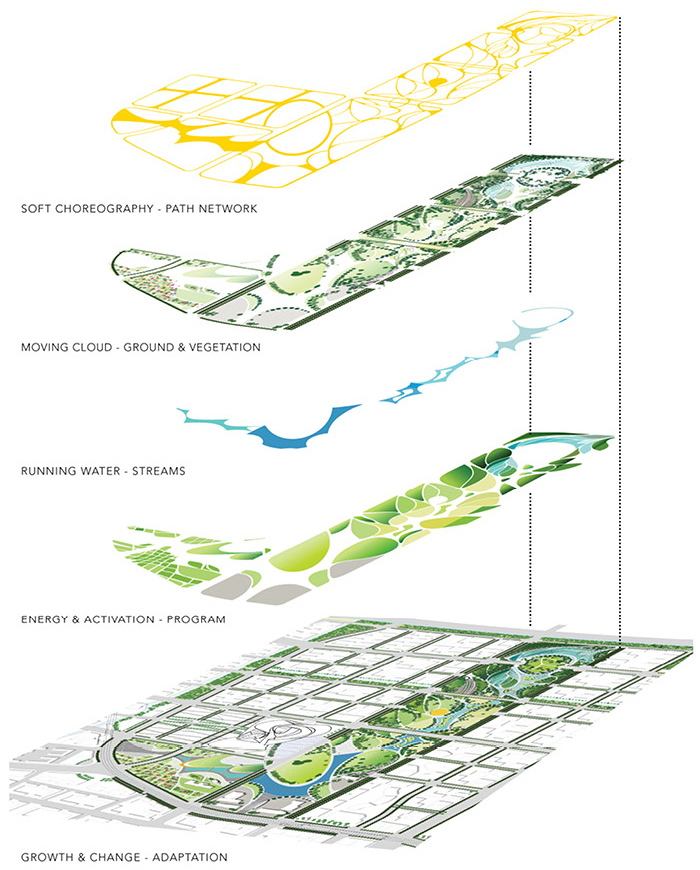
▲桃浦中央绿地分层示意:通过对道路网络、地形、植被、水系统以及功能空间的谨慎规划和分层,桃浦中央绿地整合了多种功能,每个层级都为创造动态且别致的景观发挥了重要作用。
▲桃浦中央绿地是桃浦智创城具有决定性作用的统一元素。桃浦智创城是上海西北部的一个新开发区域,专注于创造活跃、繁荣且功能多样的科技中心。
▲一个连续的公园:所有穿过场地的道路都将得到改造,以创建连续的公园和城市栖息地。古浪路上方的小丘形成了一个观景平台,其下方的隧道连接了东西向的交通。

▲探出树冠的瞭望台,其设计受到传统寺庙的曲线元素的影响,在顶端延伸为一个观景平台。

▲人们可以通过旋转楼梯攀爬至瞭望台的顶端,在大自然的包围下,欣赏城市与公园本身的独特景色。
▲水体。桃浦中央绿地包含一块湿地,在上海降雨频繁和地下水位较高的现状下,创造了城市与水的新联系。

▲零售空间、地下商业区和文化空间通过一条连续互通的路径网络与公园的特色街道和景观连接起来,并且实现了各个空间的顺畅过渡。
▲水的体验:在展示和教育的视角之外,游客们还可以通过许多其他方式来体验公园中的水:从柔软的湿地,到岛屿,到休闲湖泊,再到造型独特的城市码头。

▲自然游乐场:原木桩、攀爬柱和滑梯为孩子们提供了量身定制的游玩场地。这些游戏元素采用当地有机材料建造,摒弃了游乐场通常会使用的人工和合成材料。
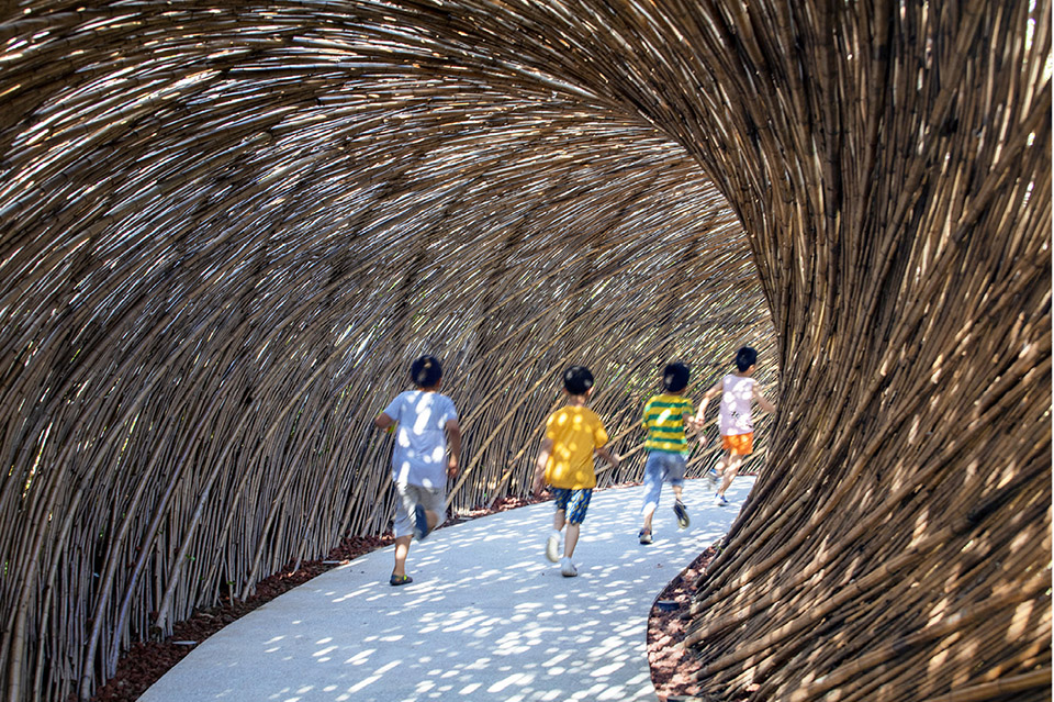
▲毛毛虫隧道:竹制隧道的编织纹理能够让光线进入,柔软的体量也使其可以环绕在游乐场的北部边缘。
▲两座垂柳岛提供了安静又放松的空间,其间分布着柳树林和细叶针茅。
▲相互连接的岛屿:一系列相互连接的岛屿——包括垂柳岛、枫树岛和桃花岛——为开阔且活跃的场地提供了宁静的空间,同时也增强了整个公园的体验性和生物多样性。
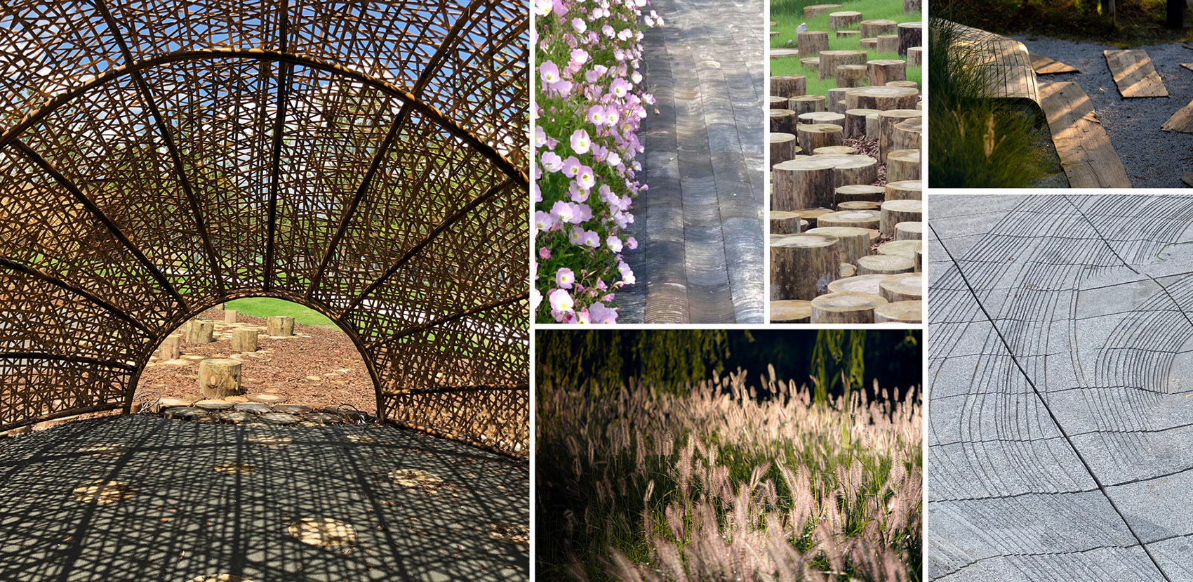
▲细节:桃浦中央绿地的设计选择了多种天然材料,包括瓦片和原木铺地、竹结构、树桩和繁茂的植物等等,进一步凸显了公园的自然气息。
PROJECT NARRATIVE
Taopu Smart City
Over the past 30 years, Shanghai has been forced to confront the pressures of unprecedented urban growth by shifting from a concentric model of metropolitan form to a polycentric model. The result is a series of hyper-connected urban hubs with distinct identities, strongly linked to the city center via transit. As Shanghai has grown, it has repurposed industrial sites at its outskirts, including Taopu. The 4.2-square-kilometer “Taopu Smart City” is a new science and technology hub in northwest Shanghai with an expected population of 29,000 people.
Taopu has gone through a number of transformations in a short time. From 1950–1997, it was primarily a site for chemical, pharmaceutical, textile, and light industry uses, and was known to be one of the most heavily polluted areas of the city. From 1997–2000, Taopu was one of the first urban industrial parks in Shanghai, reflecting the municipal government’s shift to printing and packaging industries within its most polluted areas. In 2009, Taopu’s economy began shifting again, this time into the productive service and high tech industries, in line with a growing desire to create a city that is both industrial and livable. In 2014, the district government launched Taopu Smart City to complete the transformation of the Taopu region from polluted industrial lands into a hub for science and technology. Today, Taopu Central Park has become the defining and unifying element of Taopu Smart City, reflecting its ethos as a green eco-city and actively participating in its remediation and reclamation.
New Nature
The new Taopu Central Park is a functioning ecological system and a bustling hub of commerce, innovation, leisure, and entertainment. The park choreographs the movement of people, water, air, soil, and wildlife while filtering pollutants and providing much needed habitat. A primary aim of Taopu Smart City is to fuel economic growth and innovation by offering a well-connected and exceptional public space as a catalyst for high-quality urban development. This “Park-City Symbiosis” distinguishes Taopu from other territories in Shanghai and identifies Taopu as a benchmark for technological, cultural, and environmental innovation. Taopu Central Park’s success in integrating contemporary, sustainable, and innovative forms of urban development with nature offers a vision that can become a model for urban growth for Shanghai and the world. The result is a dramatic and sizeable 237-acre park that redefines the city’s relationship to water, functions as an essential urban green lung within a dense urban context, provides a sense of big nature, and defines a memorable and connected ecological district, all while supporting 21st-century metropolitan life with spaces for habitat, water, events, and display.
Innovative Ecology
According to the Asian Green Cities Index, Shanghai is among the cities with the least accessible green space per resident. The City has responded to this issue with a set of metropolitan-scale plans to enrich the public realm and connect isolated ecosystems. The Shanghai Green Corridor is at the forefront of this planned ecological initiative, Taopu Central Park playing a critical role as the largest built piece. Inspired by traditional Chinese culture’s tenets of graceful movement and beauty, the park’s dynamic and fluid network of pathways, waterways, and topography improve water quality, manage stormwater, provide an elegant soil remediation strategy, and create connections that transform industrial lands into a living ecosystem and a new kind of urban ecological park for China.
Water
In a city that experiences frequent rain with a high water table less than two meters below the surface, Shanghai is in great need of flood control. In response, the Taopu Central Park’s water system connects to existing canals, with a central valley that channels and guides water through a series of aeration features and cleansing wetlands to filter and improve water quality while collecting water for reuse onsite. These reshaped waterways are one of the defining features of the park’s design, with water purification techniques on display as visible pieces of the landscape. Taopu Smart City is part of the Sponge City Pilot project for which China is targeting 80% of urban areas to absorb and reuse at least 70% of rainwater by 2030 to help combat climate change.
There are many ways for visitors to experience water outside of a performative and educational lens: from soft wetlands, to islands, to recreational lakes, to the more sculpted urban quay. A huge underground water pool beneath Taopu Central Park can store about 30,000 cubic meters of water per day, reducing nearby flooding risks by diverting water into the park’s lake and storing water for use during droughts. The park uses innovative materials such as porous asphalt for roads, which allows water to penetrate at a rate of 4,000 metric liters per minute, and ASWOOD, made from sawdust which allows water to penetrate road surfaces to reach plant roots underneath it.
Topography
Large-scale earthwork was necessary to confront some of the site’s industrial legacy, including excavation, relocation, and capping of contaminated soils. Soils were managed on site, rather than being removed or stored elsewhere, as a long-term ecological benefit. In contrast with Shanghai’s flat topography, this rough earthwork provided a topographic base upon which the park’s sculpted landforms can create vistas and valleys with incredible views of the city and the park itself. Watchtowers set within the forest leverage new views and allow for an experience of immersion within nature and the city simultaneously.
Green Lung
The park provides a sense of expansive nature in the context of a dense urban environment. Trees cover 70% of the site, providing ample shade for the park and contributing to carbon sequestration in the region. Trees and landforms also define the park edges and shape the interior. A palette of native and adaptive species were selected for Shanghai’s climate, including dawn redwood, gingko, willow, cypress, and peach trees that flank the central waterway. The species selection recalls the site’s history as an agricultural village with a small creek edged by peach trees on both sides, evoking Taopu’s namesake (literally “peach river”). A series of interconnected islands—Willow Islands, Maple Islands, and Peach Blossom Island—offer quiet spaces within the larger, more active park, contributing to a variety of experiences and biodiversity throughout. A robust palette of street trees creates continuity between the park and its urban surroundings, and adds character and identity to the larger ecological district.
Connectivity & Accessibility
Taopu Central Park breaks the mold for many parks in China. Land bridges and tunnels allow for needed road infrastructure while still creating a large continuous park, which prioritizes pedestrian safety, strengthens neighborhood connections, and creates habitat and wildlife corridors. In the central portion of the park, Taopu Hill & Overlook—a mound built over Gulang Road—creates a viewing deck from the top, with a tunnel connecting west-east traffic below. As the highest elevation in downtown Taopu, this opens up new views and vistas of Shanghai.
A continuous and integrated path network connects retail, underground commercial areas, and cultural spaces with park features and streetscapes, allowing for smooth transitions between. Main entrances are located within a 5-minute walk from subway stops or public transportation, enhancing accessibility for the Shanghai area. All land bridges and paths are graded to meet ADA standards and special features are designed to ensure universal accessibility for people of all abilities. A nature playground features a series of custom elements constructed from local organic materials, including a unique “Caterpillar Tunnel” made out of bamboo by local craftsmen, alongside a “Bamboo Cocoon” that creates a cozy woven-bamboo space encouraging free play.
More: ASLA; James Corner Field Operations
扫描二维码分享到微信